Across the shoal — to the fort: an expedition to Battery Island near the Korabelnyi District
The researchers walked along the island as far as the terrain allowed
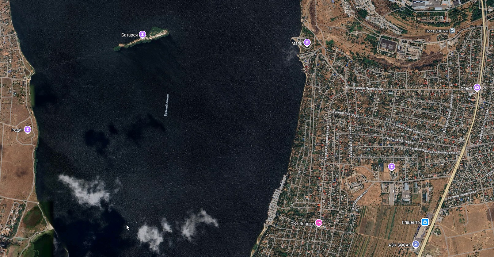
Battery Island Batareya, located in the Buzkyi Lyman opposite the border of the Korabelnyi district of Mykolaiv, has again attracted the attention of local historians and city residents. After a story about the old fort, ground sinkholes and a possible underground passage to the island, the local historian Ira Ivkova received new questions from readers: whether it is possible to get to the Battery now and what such a walk across the water actually entails.
In a new post Ira Ivkova described in more detail her own expedition-research to Battery Island, and also explained why this location is not just an interesting point on the map but a true engineering and military-historical site, partially hidden beneath the waters of the lyman.
She notes that it is possible to reach the island. But doing so on foot without knowledge of the area is extremely difficult and dangerous. Especially now, during the full-scale war, when security restrictions are in place, and any independent attempts to reach remote sites in the lyman can be risky.
According to the historian, only about two years before the start of the full-scale invasion the son of one of the researchers, together with friends, independently reached the Battery by this route. Another option is to get there by water, by boat. But even here things are not simple: it is difficult to land near the island because of old stone embankments, remnants of wooden piles and dense reedbeds.
According to Ira Ivkova, these very obstacles are related to the history of the island’s creation and its defensive purpose. The Kostiantynivska Battery was a complex engineering structure associated with the name of the eminent fortifier Eduard Totleben. Its underwater foundation consisted of ryazhs — large oak cribworks, fastened with iron and covered with granite.
Nearby, a continuous palisade of piles was driven into the silt. The whole system was supposed to function as an underwater shield: to block the movement of enemy ships and leave only a narrow channel for them, which would be covered by cannon fire. In other words, the Battery was not simply an island with guns, but part of a deliberate defensive trap on the water.
In the 20th century, when the fairway was deepened for the passage of large vessels, the central part of the underwater cribworks, according to the researcher, was blown up. But the old structures close to the island held. That is why stone foundations, piles and other elements of the old fortifications still remain around the Battery, creating serious obstacles for water transport.
In today’s conditions this old military engineering takes on a new significance. Ira Ivkova points out that the remnants of underwater structures around the island can still complicate movement in this part of the water area. In peacetime this was a problem for boats and researchers, and during the war such a natural-historical obstacle is already perceived as part of Mykolaiv’s defensive landscape.
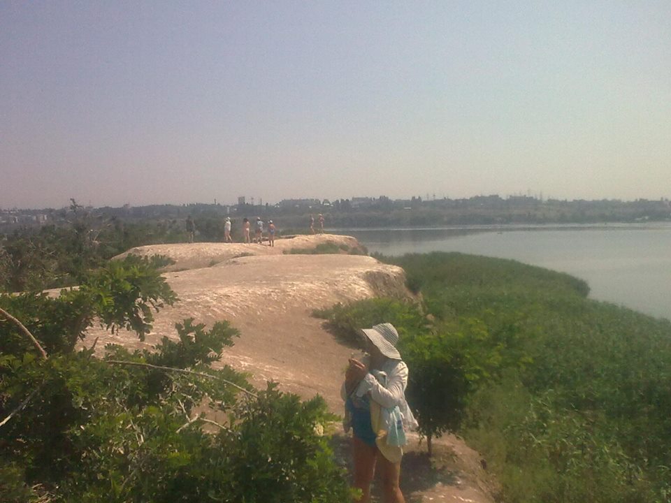
A separate part of the story is the walkable expedition to the island itself. According to the historian, it was a real adventure, though not without preparation. The researchers beforehand asked locals where the shoal begins, checked the approach to the water and clarified the peculiarities of the lyman’s behavior.
Locals warned that such a route depends heavily on time, current and water level. After a change in the current, the water can rise and the found way back can disappear. Researchers were also advised to wear sturdy shoes with thick soles, since the bottom is uneven, with sharp stones and shells.
These details are important not as instructions for repeating the route, but as an explanation of why a walk to Battery Island should not be perceived as an ordinary stroll. This is a dangerous section of the lyman where, without experience, local knowledge and safe conditions, one can easily find oneself in a difficult situation. And during the war such trips should not be planned independently at all.
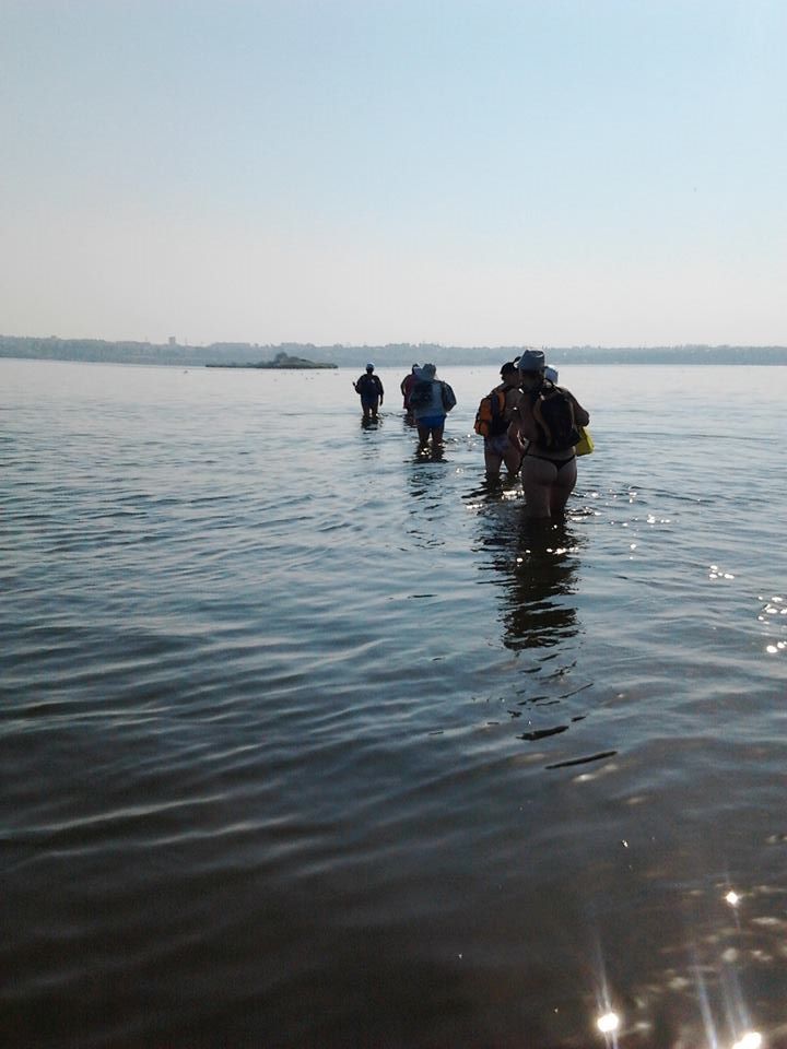
Despite this, Ira Ivkova‘s expedition did take place. The group set out with backpacks, and ahead, clearing the way, was her husband, who is in the military. From the shore the island seemed close, but in reality there was more than a kilometer of difficult route over an uneven bottom covered with stones and sharp shells.
The route required attention and endurance. Expedition members helped each other, gradually overcoming the difficult part of the lyman. Eventually the group reached Battery Island — the same old fortification structure that has been the subject of legends in Mykolaiv for decades.
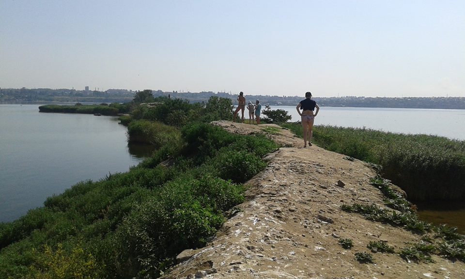
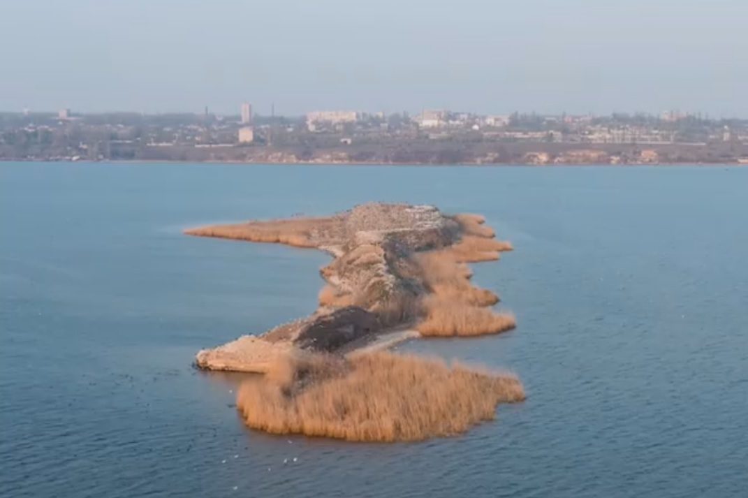
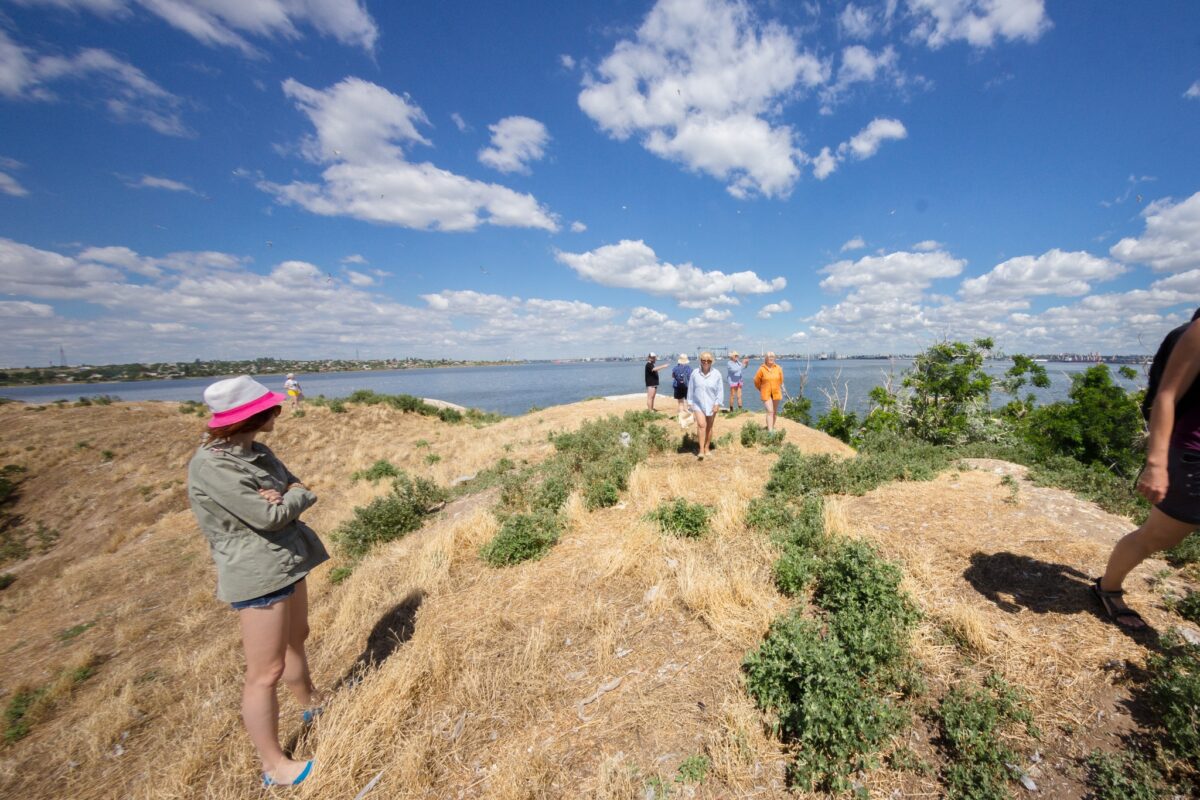
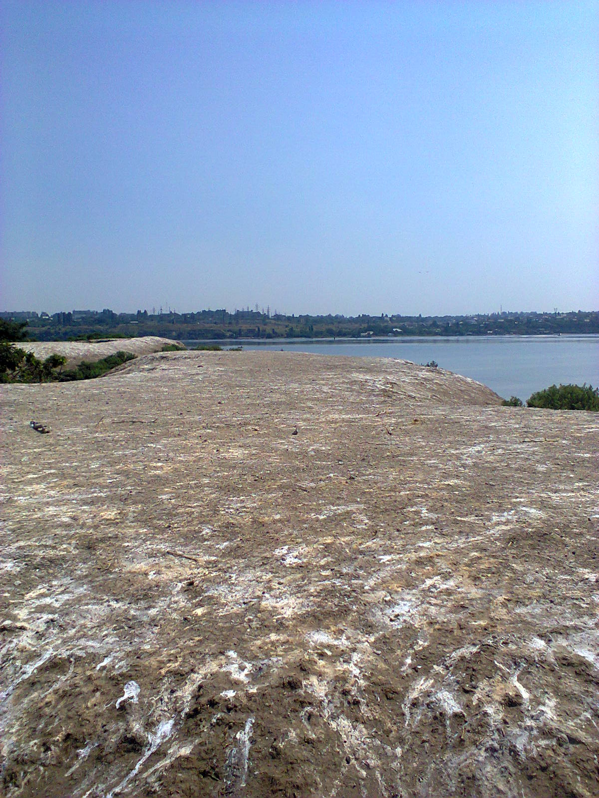
The island itself greeted the researchers sternly. Little dry land remained, and in places the path narrowed to a very tight passage. Much of the surface was covered with bird droppings — mainly from cormorants that have long colonized the place. This significantly complicated movement across the island.
At the same time, the impressions of the location outweighed the everyday inconveniences. A wide expanse of the lyman opened up around them, a panoramic view of Mykolaiv, and a sense of a place where military history has gradually dissolved into wild nature. Once the city’s defense from the water was planned here, but now the territory is effectively occupied by birds, reeds and silence.
The researchers walked the island as far as the dry land allowed. Earlier Ira Ivkova also mentioned that during expeditions on the Battery they inspected deep oval sinkholes in the ground at the sites of former casemates. These sinkholes became one of the reasons for a new wave of interest in the island and legends about underground passages.
A separate legend concerns a possible underground route to the Battery from Sadky in Mala Korenyha. According to memories passed on to the historian by a reader, her husband in the 1970s, as a teenager, allegedly reached the island by such a passage. It is no longer possible to verify the details, but the very mention of the Sadky area is significant: that locality is located opposite the island.
At the same time Ira Ivkova is cautious in her conclusions. She does not claim that a full-fledged tunnel definitely existed under the lyman. According to her explanation, modern hydrogeologists are skeptical of the version about an underwater passage through the muddy bottom. But the military infrastructure on the shore could indeed have been very extensive.
In the area of Mala Korenyha there were coastal defensive objects, including the St. George Redoubt, which was supposed to support the Battery Island and control the fairway. There may have been underground passages, artillery magazines, cable collectors, mine stations and buried tunnels. These real structures could over time have turned in popular memory into a story about an “underground way to the island.”
The explanation can be simpler. During a strong ebb or when wind pushes the water away, the shoal between the shore and the island could have been exposed so much that one could walk to the Battery almost over dry land. If teenagers first entered an old shore casemate and then walked the shoal, in memory this could have formed into one continuous route.
After inspecting the island the group set off back. According to Ira Ivkova, the return route seemed easier because the route was already familiar. The researchers managed to return to the shore before the water level began to change. In her opinion, this was one of the main factors in the successful completion of the expedition.
Ira Ivkova emphasized that the goal of the expedition was fully achieved: the researchers checked the possibility of a foot crossing to the island, saw the old fortification location up close and once again became convinced that the Battery remains one of the most mysterious places in the Mykolaiv lyman.
“The goal of our expedition was achieved one hundred percent!”
Today the Battery Island should not be called part of the Korabelnyi district without separate legal confirmation. But geographically it is located directly opposite its border — in the Buzkyi Lyman, between the shore area of Mala Korenyha, Radsad and the water area that is clearly visible from the Korabelnyi direction.
Therefore this story is especially close to the residents of the Korabelnyi district. Battery Island is not just a remote point in the water. It is part of the larger history of Mykolaiv as a city by the lyman, a city of shipbuilders and a city that for centuries thought about defense from the water.
Everything is intertwined in this story: the engineering legacy of Eduard Totleben, underwater oak cribworks, stone embankments, military legends, childhood memories of the 1970s, expeditions of local historians, wild cormorants and the current war, in which Mykolaiv is once again forced to value every element of its defensive landscape.
The Battery Island still has not revealed all of its secrets. An underground passage to it has not yet been found. But the very fact that the old fortification, created more than a century ago, still affects the lyman’s water area makes this place one of the most interesting historical sites near Mykolaiv.
Previously we wrote:
- Renaming again: 49 streets in Mykolaiv changed names, 10 — in Korabelnyi
- “An armored train stopped at Kulbakine station and began shelling Bohoyavlenska…”
- Secrets of Mykolaiv catacombs: myths and facts (MAP)
- “In Vitovka there was always the best fish market”… How the decline came to the once-famous fishing industry in Mykolaiv
- Caught with a net: a fisherman near Korenyha was fined 110 thousand