Where the Cossacks guarded the estuary: the history of Balabanivka, Vitovka and Shyroka Balka
Cossack "samovars" and signal lights: Iryna Ivkova spoke about the past of southern Mykolaiv


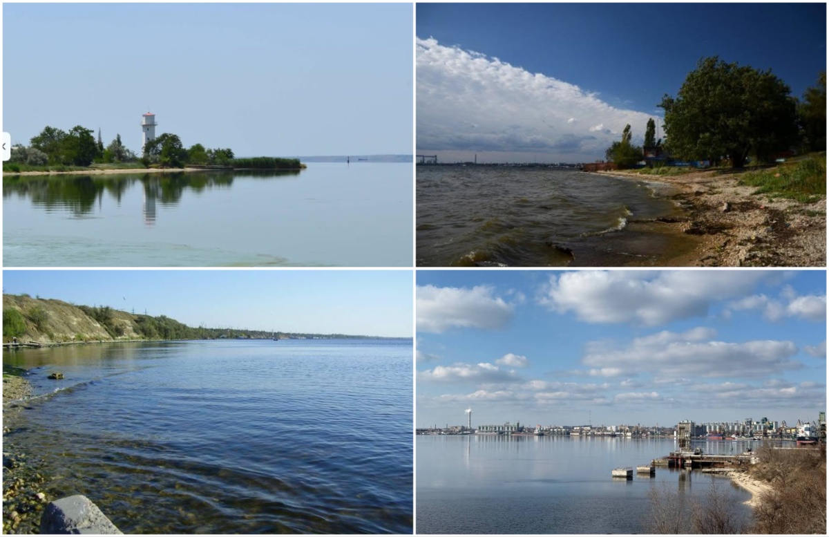
Mykolaiv local historian Irina Ivkova told the history of the territories of the modern Korablev District, where at different times trade and Chumak routes ran, there were Cossack winter camps, fishing industries and watch posts. She wrote about this on her Facebook page, continuing a series of local history stories about the shore of the Southern Bug.
This time Ivkova focused on the area from Vitovka and Balabanivka to Shyroka and Popova valleys. According to the historian, the territory of modern Balabanivka, where port terminals and the Ocean shipbuilding plant are now located, long before industrial development belonged to the Buhogardivska Palanka.
A gentle shore, Ivkova writes, was used by the Cossacks as a natural mooring for kayuk boats. They could be hauled ashore here for repairs, nets mended, and horses grazed nearby. Above the shore was located Vitovka.
According to the version cited by the local historian, at the end of the 14th century the Lithuanian prince Vytautas developed a system of control over the routes along the Southern Bug, and on the high banks near present-day Mykolaiv there were fortifications and a customs post.
A place of particular importance was known as the Vitovt Ford. Ivkova explains that the liman narrowed here, and a natural stone ridge ran under the water, making the area suitable for a ferry crossing. Trade routes ran through this area, transporting various goods and driving livestock.
Later, according to Ivkova, the Zaporizhian Cossacks established a large Cossack winter camp on the territory of Vitovka. One of the main local industries was fishing. On the shore so-called “samovary” operated — stationary fish-processing facilities where large cauldrons were used to process the catch. The historian notes that sturgeon, beluga and sevruga were salted, dried and processed here.
Natural springs were also of great importance. Water passed through thick layers of limestone and emerged along the slopes. According to Ivkova, these springs supplied water to local settlements and households.
At the end of the 18th century Vitovka was renamed Bohoyavlensk. Ivkova also mentions the establishment here of the country residence of Prince Grigory Potemkin.
The next historical point named by the historian was Siversov Spit, the area that Mykolaiv residents today know as the “Mayak” district. According to her, in Cossack times a beket — an observation post operated on the cape. The Cossacks stood guard here and, in case of danger, could light signal fires to warn other posts of ships approaching from the Ochakiv side.
Later, in the 19th century, a system of Siversov lighthouses appeared in this area. One lighthouse was located closer to the water, the other higher on the bank. They were used for the safe passage of ships along the fairway.
Ivkova also spoke about the keeper of the Siversov lighthouse, Yuriy Kovalskyi, who over the years collected historical items found on the shore. According to her, his collection included Greek amphorae, Cossack pipes, weapon tips, cannonballs from the Crimean War and fragments of World War II munitions.
Beyond the “Mayak” district the shoreline transitions to Shyroka Balka. Ivkova notes that the valley area is connected with the ancient hydrographic system of the locality, and many sources of fresh water have been preserved in its slopes. It was near these springs, the historian says, that the Cossacks dug wells and founded the Shyroky winter camp. One of the Chumak land routes also passed through Shyroka Balka. After loading salt at the Kinburn Lakes, Chumak caravans moved across the steppe along the river. In Shyroka Balka they could stop to water their oxen, rest and repair their carts.
A separate period in the history of the shore is associated with the Crimean War. Ivkova recalls that a Kostiantyniv Battery was created on a shoal in the middle of the liman, and earthworks and artillery positions were arranged along the left bank to defend the approaches to Mykolaiv.
The next point of the historical journey was Popova Balka.
According to the historian, as early as the 6th–4th centuries BC there was a settlement here connected with ancient Olbia. Later this area was also used to control the coast and the liman. In Cossack times, Ivkova writes, the Zaporizhian Cossacks used Popova Balka as a naturally sheltered harbor and a place for watch posts.
“Most importantly, the Cossacks firmly held both banks of our liman. In every time period a unique story was unfolding here,” summarized Irina Ivkova.
The local historian noted that she will continue to tell stories about the historical sites of Mykolaiv and its environs.
Previously we wrote:
- Siversov lighthouse, the Football Cup and the memory of over 10,000 Jews: what marked September 16
- Vitovka, the city geoportal and seven downed “Shaheds”: what marked September 6
- A warrant for Vitovka and Mykolaiv, Russian shelling and a new route: what marked August 27
- The myth about Hitler in Shyroka Balka, a dolphin and rockets at “Mohylyanka”: what marked August 19 in Mykolaiv
- Through the shoal — to the fort: expedition to Battery Island near the Korablev District